
CHAPTER 1: INTRODUCTION TO GEOLOGY, P 1-10 Scan, P 11-19 read, study plate tectonics.
GEOLOGY - the study of the earth
PHYSICAL GEOLOGY (Geology 220)- examines materials composing the earth;
includes processes that operate beneath and on the surface.
HISTORICAL GEOLOGY (Geology 210)- the study of earth's origin and its
development through time; strives to establish an orderly
chronological arrangement of the multitude of physical and
biological changes that have occurred in the past.
WHY STUDY GEOLOGY? Geology is an "environmental science:" it is essential for
understanding earth processes, and important to understanding
both natural and anthropogenic catastrophes.
GEOLOGIC TIME - current estimate is that the earth formed around
4.6 billion years ago; the oldest rocks found on the surface are
about 3.8 billion (old rocks crop out on coast of Greenland, core of Wind River
Mountains in Wyoming, Australia, Africa). The older date for the earth is derrived
from dating the moon and meteorites.
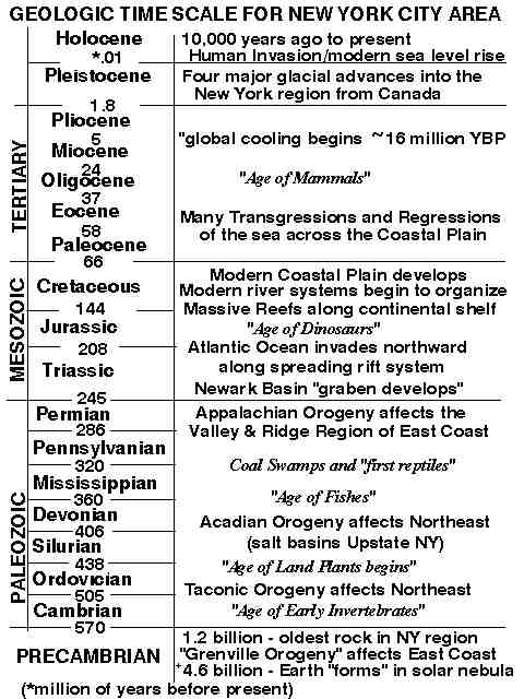
GEOLOGIC TIME SCALE [p. 6] - Names provided by geologists who
studied fossil-bearing rock sequences in many areas around the
world.
STRUCTURE OF THE EARTH
- INNER CORE - iron and nickel, solid, ~1200 km radius
- OUTER CORE - liquid metallic iron, ~2300 km thick
- MANTLE - dense rock, ~2900 km thick
- CRUST - "skin" of light rock, 5-40 km thick.
- ASTHENOSPHERE - hot weak zone 100-700 km (below crust and upper mantle), capable of
flow.
- LITHOSPHERE - cooler, rigid rock upper mantle and crust
- HYDROSPHERE - oceans, lakes, rivers, glaciers
- ATMOSPHERE - air up to the vacuum of space
- BIOSPHERE - includes all life of earth within the earth,
water, and air
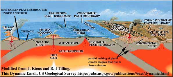
THEORY OF PLATE TECTONICS
Explains continental drift an important theory championed by Alfred Wegener early in the 20th Century.
The LITHOSPHERE consists of rigid PLATES floating on a dense,
viscous ASTHENOSPHERE. The lithospheric plates are in motion. The energy to move the plates comes from:
heat left over from the earth's formation and from radioactive decay.
PLATE TECTONICS works like a "boiling pot with a skin on top" - hot rock
rises; cooler denser rock sinks. Within the mantle, hot areas are
rising beneath ocean ridges, cooler rocks are sinking beneath
plate convergent zones (such as around the edges of the Pacific
Ocean). The sinking rocks on the ocean plates are
full of water and trapped gas that cause some of the rock to melt
as it sinks. This molten rock rises to the surface and erupts as
volcanos, outlining the approximate the sinking plate boundaries. We call these boundaries SUBDUCTION ZONES. (This subduction process is happening in many places along the Pacific Plate and gives
the Pacific Rim its name "The Ring of Fire.")
PLATES consist of rocks of differing densities:
1 Oceanic crust - density = 3.5 g/cm3
2 Continental crust - density = 2.7 g/cm3
and 3 the underlying upper mantle
The plates vary greatly in thickness.
Ocean lithosphere varies from 10 to 100 km in thickness and continental lithosphere from around 100 km up to 250 km in thickness.
The tectonic processes that affect the earth's surface are most
active along the margins of PLATES. There are three types of
plate boundaries:
- DIVERGENT BOUNDARIES--where plates move apart and hot mantle
material rises. (When the hot magma reaches the surface it oozes out as very HOT lava and cools to form
new ocean floor.) The area of magmatism around the divergent boundary is elevated both because lava is piling up on the seafloor
and because the heat below buoyes (remember hot substance tend to rise) up the region into a ridge. The ridge system made at the divergent
margins is like and undersea mountain range, and is the longest mountain range on earth connecting
through the world-wide ocean basins it is some 40,000 miles long. The plates move apart slowly. The process of adding new ocean CRUST is called SEAFLOOR
SPREADING. As the new crust (and lithosphere below) is added, the oceanic plate on either side of the ocean
ridge move apart (driven by convection from the mantle convection cells).
For example, the Atlantic Ocean is spreading apart
along the Mid-Atlantic Ridge at a rate of about 5 cm per year. When a divergent boundary
begins to form under a landmass, continents are torn apart;the process is called RIFTING.
Rifting is taking place in East Africa, in the rift valley.
Eventually the rift will extend to the ocean
and the rift valley will be flooded to form a new sea.
This has happened in the past; an example would be the rifting of Africa and Europe away from
North America to form the North Atlanntic
- CONVERGENT BOUNDARIES--where plates collide, mountains form,
such as the Himalayan Mountains. Part of the mountain belt is formed
from crumpling of the plate's upper surface. As well, if denser ocean crust collides
with lighter continental crust, the ocean crust sinks beneath the
continental crust and partially melts, forming volcanos along the
continental plate margin. Examples include the Andes, the
Cascade Mountains in the US, the island arcs of the Aleutians,
Japan, Philippines, and Malaysia. Where one plate overrides,
another a deep ocean trench forms adjacent to a coastal volcanic
mountain range. This large feature is called a SUBDUCTION ZONE.
- TRANSFORM BOUNDARIES--where plates slide past one another,
causing major earthquakes: Examples include San Andreas Fault
and faults in the valley of the Dead Sea, Jordan, Israel, and
Egypt. Smaller transform faults offset the ocean ridge system
THE ROCK CYCLE
The ROCK CYCLE represents a flow chart showing natural processes
and earth products.
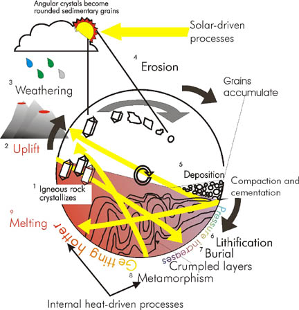
Important concepts of the rock cycle include:
- IGNEOUS ROCK FORMATION--forms from the solidification of molten rock MAGMA--molten rock underground
crystallizes to form Plutonic rock(labeled 1 on diagram) or LAVA--molten rock on the surface crystallizes
to form volcanic rock.
- BY CRYSTALLIZATION - the process of cooling and solidifying
magma.
- UPLIFT--exposes rocks to the surface where weathering takes place (labeled 2 on diagram)
- WEATHERING--processes that break down rocks (chemical or mechanical) (labeled 3 on diagram)
- Erosion--transports material away from an area (labeled 4 on diagram)
- SEDIMENTATION AND DEPOSITION- rock particles or precipitates deposited, typically in a
low-lying area called a basin (labeled 5 on diagram).
- LITHIFICATION, COMPACTION--processes that bind sediment into rock (labeled 6 on diagram)
- BURIAL--Though strictly speaking burial and compaction are similtaneous, burial can continue
even after all original grains are compacted together (labeled 7 on diagram).
- SEDIMENTARY ROCK--rock consisting of cemented and compacted sediments, typically formed during burial.
There is a continuum between sedimentary and metamorphic rocks.
- METAMORPHIC ROCK--great heat and pressure physically (crumpling and contortion) and
chemically change the rock(labeled 8 on diagram).
- Eventually REMELTING OCCURS--the cycle is complete.
 Click here to
return to the Class Website
Click here to
return to the Class Website
 Click here to
visit our publisher's website
Click here to
visit our publisher's website